


Last Chance to speak on the Transportation Plan, Winner of giveaway, Safe Spaces Bylaw
North Cowichan Special time: TUESDAY 4PM

Hello folks,
Wouldn’t it be great if our local governments could develop mitigation plans based on weather events that we cannot control? Events such as solar flares, pole shifts, polar vortexes, El Niño and La Niña, studied by true climate scientists, could inform us about what to expect and which continents will be affected. By considering these natural shifts, we could prepare for more grid-down scenarios instead of insisting that everyone be fully electric. In anticipation of a potential ice age, we could ensure people have multiple sources of heat. By considering factors expected to increase by 2030 (odd coincidence hey?), we could implement flood plans for coastal areas, like those in the Netherlands. Instead, we are currently focusing on limiting mobility and power choices.
(Summary at the bottom of this Substack for those interested in what these uncontrollable factors of change could mean for our future.)
On TUESDAY at 4pm (3:30 sign up to speak) North Cowichan (Short meeting) will be receiving the latest update from WATT consulting regarding their transportation plan since the latest so-called public engagement, which consisted of 23 online comments and 30 people attending their open house (held in the middle of a work day at the pool). North Cowichan will also be receiving Council’s endorsement of Minister’s Meetings to be requested during the 2024 Union of British Columbia Municipalities (UBCM) Convention. Each year at the UBCM Convention local governments are invited to request meetings with Minister from all Provincial Ministries. While short, these meetings are an opportunity to discuss issues, bring forward ideas or concerns and ask questions of Ministers. Based on discussions with the Mayor and feedback from Council, eight topics have been identified for Minister’s meetings: Here are the priorities, what are your thoughts based on your life currently ?

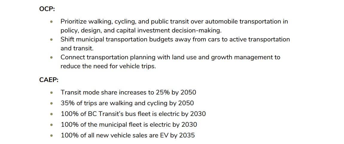
TRANSPORTATION PLAN:
There is a lot to break down in this plan that would cost an extra 4.7 million a year on top of the 3-4 million currently allocated to roads, but here are some of the takeaways:
As we see council lowering the parking space allocations from new builds, ie reducing parking down to as low as 1.5 parking spaces per unit, we see this transportation plan suggest parking rates inside growth containment boundaries (aka 15 min cities) for visiting cars, pedal bikes and scooters, with resident parking passes (not yet to be told if these would cost) and time limits on parking with more enforcement hired for monitoring and ticketing.
The UK is about 5 years ahead of us with agenda 2030: “The UK is facing significant parking challenges, particularly in its 15-minute cities, where the struggle to find a parking space is a daily reality. According to INRIX, parking costs the UK £23.3 billion a year, with the average 2-hour parking cost being £12.50. This is due to the increasing demand for parking spaces, limited supply, and the complexity of parking regulations. The availability of parking spaces varies greatly across the UK. According to the Driving Instructors Association, some cities have as few as 86 parking spaces per 1,000 cars, making it challenging for visitors to find a parking spot. For example, Chester has the fewest parking spaces per 1,000 cars, while Cambridge has the most, with 45.75 parking spaces per 1,000 cars. ”
In essence the Transportation Plan projects a utopia where we, on the wet-coast, reduce our vehicle usage by 40% and bike, walk, and scooter within our growth containment boundaries. Where the plan suggests a community of which currently consist of 80% of people who commute to work, either find jobs within their 15 min city, or they use the currently non-existent public transit to commute.
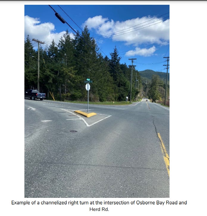
A plan where they use “traffic calming” methods such as road narrowing and reduction of right-hand turn islands like at Osbourne Bay Road and Herd Rd. (pg 47 MTP “Standard right turn lanes, without islands, provide the same level of service to vehicles in a municipal environment, but utilize less land, reduce crossing distances, and slow turning vehicles down.”)
The plan consists of many factors to frustrate drivers from lowering speed limit to narrowing lanes - Last week we were driving down the new Canada Ave “upgrade”, there is no separate bike lane as was in the original plan, and so a bike was ahead of us on the road where it was narrowed heading south. A police came out of the station with lights flashing, however the bike has us slowed down and no way to pull aside for the police car to get by us, so we continued to drive until we passed the “narrowing” area, slowing the police from reaching their emergency quicker. Many of these Transport plans remove shoulders and areas to pull over especially with the barriers suggested between the current bike lanes. The emergency services to not seem to be on the list of groups consulted with.
Some areas are considered priority based on “feedback” yet the feedback for these areas, such as Berkey’s Corner was 1 person. These areas suggest a two way bike lane added to places such as Sherman to Berkey’s corner, all of Lane rd. and priorities such as York St and roads heading to Quamichan School (as if the priority would be bike lanes in this area, not removing the street drug issue first) -Their reasoning was that the existing bike lanes and roads were not safe for kids to ride their bikes to school …ummmm…, kids won’t ride their bikes there for other reasons, and kids ride bikes on sidewalks - but that is what you get when you hire expensive out-of-towners who do the same plan in hundreds of munis.

There is also a suggestion to have bike lessons for k-12 to help them learn how to bike in their new ghettoes, as well as prioritizing bus shelters, which is ironic as we just pulled down two because of the addicts taking them over. Are the priorities over public safety and citizens actual concerns being overridden by this dream that we can change the climate if we all just sacrifice, while other countries laugh at us?
There is an argument that we could use more sidewalks and user friendly walkways, however, this plan is based on a utopian dream where North Cowichan can somehow change the climate, costing us 47 million in addition to the 500 million for the climate action plan, and neglects the fact that all these 15-min cities would still have to be supplied with food etc. from outside sources, suggesting it will just be YOU that must stick within these boundaries such as we see once again in the UK. “People can drive freely around their own neighbourhood and can apply for a permit to drive through the filters, and into other neighbourhoods, for up to 100 days per year. This equates to an average of two days per week.” [https://www.oxfordmail.co.uk/news/23073992.traffic-filters-will-divide-city-15-minute-neighbourhoods/]
The plan suggests that tax payer’s funds towards road infrastructure take back seat and that funds in this piggy bank be allocated to active transportation, with wording such as ‘prioritizing snow plowing to where cycling facilities exist’.
The one large part of this plan that was quite revealing was that in the OCP a population increase of 30% was projected by 2050 reaching 38,612 citizens, however this Transportation plan show us reaching over 90 thousand !? Makes you wonder who all these new builds are for, or why NC is approving builds that are almost all studio and one bedroom, while canceling 2-3 bedroom builds. The OCP was realistic in growth, the Transportation Plan is realistic only if we take into account the current mass immigration policies that lend NO credibility to goals of a local climate “plan” if those are the real numbers- so which is it?
From the CAEP: “• Laying a foundation for a low carbon future. [low carbon? if we drop 150ppm lower than our current 400 ppm all life on earth dies] • Using the best information and predictions we have available. [yet they do not take any alternative information such as https://www.ncbi.nlm.nih.gov/pmc/articles/PMC1112950/ and https://www.forbes.com/sites/alexepstein/2015/01/06/97-of-climate-scientists-agree-is-100-wrong/?sh=67d87e7f3f9f and so on]• Setting out the goals, targets, strategies and actions each of us can work towards to take our part and mitigate our community’s impact on global climate change. The current CAEP actions will necessarily be an iterative process requiring regular updates as technology and knowledge advances, new priorities emerge and our community and climate changes over time. We hope to set an example of the low carbon future we need as a community by 2050, while, over time, saving taxpayers’ dollars.”
(slide show summery being presented to council : https://pub-northcowichan.escribemeetings.com/filestream.ashx?DocumentId=16130)
One of the best graphs from the OCP - “Business as usual” shows we increase emissions by only 1% in 2050 if we don’t lower our living standards, sacrifice, and pay higher taxes to meet THEIR climate goals…..


The winner of our hat giveaway for sending in a review is Lorene Benoit! Congratulations and thank you to all who participated !!
The CVRD is looking at public feedback on their “safe spaces” bylaw. The safe spaces bylaw was spoken at length by the Directors as well as representatives from North Cowichan such as Cllr. Istace, who showed fervor for implementing the bylaw. The debates consisted of whether the public should still have the three min public speaking times ( to their credit, almost all said that should still be in place), however many words such as “dangerous” were used in the debate which came on the heals of a large showing against the tax increases - of which all the public were respectful, many in tears actually. All this to say, this public engagement online survey is HIGHLY manipulative as it asks questions like “should safe spaces bylaw include the Charter and BC Human rights” - don’t they have to follow those anyway? Another poses questions such as whether you would support this bylaw related to people starting fires and defacing property (??) - to which you would say yes (?), but isn’t this already against the law? Anyway, if you would like to participate in this highly manipulated survey, there is a place for comments at the end.
[We have written many articles on this topic: https://wwind.ca/the-slow-creep-to-censorship-all-levels-of-government/
An example of them shutting us down : https://wwind.ca/cowichan-valleys-safe-spaces-censorship-masquerading-as-civility/
Examples and quotes from their meeting: https://wwind.ca/cvrd-considers-removing-public-input-from-committee-meetings/ ]
Anyway - here is the survey : https://www.planyourcowichan.ca/respectful-spaces-bylaw
Sincerely,
TEAM COAP
To think we have power over changing these things… But we can prepare.
Our planet's weather is a dynamic and complex system, influenced by a myriad of factors ranging from celestial bodies to deep-seated geological processes. Understanding these diverse influences is crucial for grasping the full picture of Earth's climate and anticipating future changes. Let's delve into how the Sun, the Earth's magnetic field, the Moon, the polar vortex, and El Niño events all play pivotal roles in shaping our weather and climate.
The Sun: The Ultimate Weather Maker
The Sun, our primary source of energy, profoundly impacts Earth's weather through its cyclical activity. The Sun operates on an 11-year cycle known as the Schwabe cycle, alternating between periods of low and high solar activity. During solar maximum, sunspots, solar flares, and Coronal Mass Ejections (CMEs) become more frequent. These events can disrupt Earth's magnetosphere, leading to geomagnetic storms.
These solar storms can have several effects:
Satellite Disruption: Increased radiation can damage satellite electronics, causing malfunctions.
Power Grid Vulnerability: Solar storms induce electrical currents in power lines, potentially leading to widespread blackouts.
Atmospheric Expansion: Additional energy warms and expands Earth's upper atmosphere, increasing drag on low-orbit satellites.
Moreover, the Sun's activity influences weather patterns on Earth. During periods of high solar activity, the increased energy input can alter atmospheric circulation, potentially affecting global climate patterns. Current solar activity is looking to peak in 2024.
Geomagnetic Reversals: The Hidden Threat
Deep within the Earth, molten iron in the outer core generates a magnetic field that extends into space, creating a protective shield against solar radiation. This magnetic field undergoes periodic reversals where the magnetic north and south poles swap places. These geomagnetic reversals, occurring roughly every 200,000 to 300,000 years, have significant implications.
During a reversal, the Earth's magnetic field weakens substantially, reducing our planet's ability to deflect harmful solar radiation. The consequences can be severe:
Increased Radiation: Higher levels of solar and cosmic radiation can reach Earth's surface, increasing health risks.
Technological Disruptions: Satellites and technologies reliant on the magnetic field for navigation can be adversely affected.
Climate Impacts: Changes in the magnetic field could influence climate patterns, though the mechanisms are still under investigation.
Evidence indicates we are currently overdue for a geomagnetic reversal, with recent fluctuations in the magnetic field suggesting the buildup may have already begun.
The Moon: A Subtle Yet Powerful Influence
The Moon, Earth's constant companion, exerts a significant gravitational pull that influences ocean tides. This tidal effect undergoes a complex cycle known as the Lunar Nodal Cycle, lasting about 18.6 years. During this cycle, the alignment between the Earth, Moon, and Sun changes, amplifying gravitational effects and leading to higher tides.
When the Moon's orbit aligns with the Sun, it causes particularly high tides, known as spring tides. These can lead to:
Increased Flooding: Coastal regions face higher flood risks, especially when tides coincide with storms or heavy rainfall.
Infrastructure Damage: Flooding can cause extensive damage, as seen during the 2015 alignment when South Carolina experienced severe floods.
The next significant alignment in the mid-2030s is expected to exacerbate flooding issues, with predictions suggesting a dramatic increase in flood events across US coastlines, Hawaii, and Guam. This poses a serious threat to coastal communities, impacting housing, clean water supplies, and increasing waterborne disease risks.
The Polar Vortex: A Cold Snap's Tale
The polar vortex is a large area of low pressure and cold air surrounding the Earth's poles. During winter, the polar vortex can weaken, sending cold Arctic air southward into regions like North America, Europe, and Asia. This phenomenon can lead to extreme cold snaps, blizzards, and disruptions to transportation and infrastructure. Understanding the dynamics of the polar vortex is crucial for predicting and preparing for these extreme weather events.
El Niño: The Pacific Oscillation
El Niño is a climate phenomenon characterized by the periodic warming of sea surface temperatures in the central and eastern Pacific Ocean. This warming can have far-reaching effects on weather patterns around the globe, leading to:
Droughts: Some regions experience reduced rainfall and prolonged dry spells, impacting agriculture and water resources.
Floods: Other areas may see increased precipitation and flooding, disrupting communities and infrastructure.
Storms: El Niño can influence the formation and intensity of tropical cyclones, leading to more frequent and severe storms in certain regions.
Understanding the complex interactions between ocean temperatures, atmospheric circulation, and weather patterns is essential for predicting El Niño events and their potential impacts on society and the environment. Current one started winter 2023